-
+977 9851060895
-
adventurebeyondthelimit@gmail.com

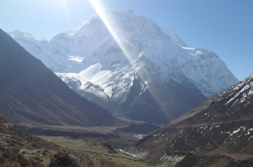
The Great Himalaya Trail (GHT) has been considered as one of the biggest adventure voyages across the globe. Considered as “Intermediate Expedition” by the global mountaineering communities, this trail traverses through some of the most rugged and remote places in the Nepalese Himalayan Belt. And the best part about embarking on this voyage is that you get to gaze at the eight highest mountains above 8000 meters located in Nepal up close.
The Great Himalayan Trail is composed of ten different treks throughout Nepal. The trail can be completed in one go or by section hiking that is by individually completing partial trek sections in different courses of time. The high route GHT portion of Nepal can be completed within 150 days. It is an excellent trekking route for aspiring Backpackers, Strollers, Explorers, and Green Panthers with Alpine Fitness.
The trail navigates from the far east to the far west or the reverse in Nepal piercing through some of the most appalling and technical landscape found in the foothills of Himalayas. The Himalayan belt extends from Pakistan, India, Nepal and Tibet creating a huge wall up in the north of South Asia. It begins from the Kanchenjunga foothills in the eastern district of Taplejung then heads westward thereon passing through Makalu, Everest, Rolwaling, Langtang, Manaslu, Annapurna, Dhaulagiri, Dolpo and Karnali region before ending in the remote bordering district of Humla in Hilsa.
Great Himalaya Trek is a collaboration of various existing treks in Nepal which altogether sums up to the length of over 1700+ kms. The Great Himalaya Trail consists of two main routes:
1) The High Route:
The route of Great Himalaya Trail traverses through higher sections of the Himalayan belt elevating as high as 6200 meters at Makalu Sherpani Col in Makalu region. The High route of GHT passes through 15 of the biggest passes in Nepal above 5000 meters and 2 passes that elevate above 6100 meters. While the lower route of GHT traverses through Mahabharat hills with dense forest at lower elevation, the high route is considered to be the real Great Himalayan Trail by most.
2) The Lower Route:
The Lower Route or Cultural Trail in GHT traverses through small quaint settlements of Nepalese inhabitants. At the highest point, this route touches a mere 5563 meters and goes to a roller coaster ride along the trail averaging 4000 meters elevation all along. The low route offers the original paths used by locals and the village lifestyle in the region. It sits at an average altitude of 2,000 meters. Weaving a short span of memories with the locals; away from busy city life is becoming popular even among domestic traversers. The route is shorter than the high route which can be completed in 90 days.
The Great Himalayan Trail’s popular starting point is Humla region in the western vicinity of Nepalese territory. The topography of the Humla region is sub tropical with sparsely populated villages. The starting point is also one of the prominent stops for tourists headed for Tibet. The trail heads eastward from Humla and pierces through one of the remotest regions of Dolpo. Dolpo is considered one of the most rugged and off the beaten regions in Nepal. The semi-arid landscape of Dolpo runs through traditional Dolpo villages and high passes. Neighboring the Dolpo region is another popular space in Nepal, The Mustang Region.
Located in the river-basin of Kaligandaki river, Mustang is similar to Dolpo in terms of topography but a little more developed with roadways accessibility and modern accommodation amenities. The trail then hikes up from Kagbeni in Mustang towards the popular Thorang La Pass (5416m) to descend down to the picturesque Manang region. In between Mustang and Manang lies the Annapurna range which homes the tenth highest mountain on earth, Annapurna I (8091M). Manang is a semi-arid valley which is equally enigmatic and beautiful as Mustang. The topography and spatial distribution is similar and remains dry for the most part of the year except for in winter. The trail then heads west towards the Manaslu region which homes the eighth highest mountain in the world, Mt. Manaslu (8163m).
Manaslu has small settlements of Buddhist people which used to be nomadic tents of traders from Tibet decades ago. You pass through the famous pass Larkya La Pass (5150m) in Manaslu region and reverse descent through the conventional Manaslu Circuit Trek route. The trail then descends via: small villages of Samdo, Samagaon, Lho and Namrung. The trail deviates from Namrung towards the hidden Ganesh Himal region of central Nepal. Ganesh Himal is one of the less touristy regions and is trekked by very few tourists. We take the famous Ruby Valley route through Ganesh Himal region to reach Somdang from where our adventure towards Langtang region begins. Langtang follows through the same Langtang valley trek trail which takes you to the base of Langtang Lirung (7234m). The trail then passes through Ganja La Pass (5130m) to reach the home of Hyolmos, Helambu region.
Your trail then heads eastward through various glacial lakes and deep valleys of the Rolwaling region. Rolwaling region lies in Gaurishankar conservation area which homes over 235 species of birds and 34 species of animals which includes Leopard, Himalayan black bear, and Himalayan Thar.
Your next stopover for the adventure is the Everest region which consists of over 300 Himalayan mountains, every one of them is gigantic and picturesque to look at. Sagarmatha National Park stands as another precious gem for its rare wildlife species. Recently, in 2023 there was a sighting of the rare snow leopard in the Sagarmatha National Park.
In the days to come, your adventure ventures through various hidden gems of Nepal including Makalu Sherpani Col, West Col, traversing through the base of Mt.Makalu (8481 metres), the trail pierces through Makalu Barun National Park to connect you to the far eastern gigantic massif of Mt.Kanchenjunga(8586m) ending your GHT voyage.
The Great Himalayan Trail instills excitement in photographers too. The GHT in Nepal consists of the World’s most beautiful National Parks and Reserve Areas. These national parks are famous for trekking purposes as well as carry different significant religious, cultural, natural, and social activities. You will witness the Himalayan Festivals and Faiths. Bird watching also is a profoundly rewarding activity. 6 out of 12 National Parks, Makalu-Barun, Sagarmatha, Langtang, Khaptad, Rara, and Shey-Phoksundo. They are somehow in the GHT of Nepal with great diversities of Flora and Fauna. The national parks are also home to many endangered species.
All the National Parks and Reserve Areas serve as spectacular bio reserves in the lap of the Himalayas. As a shutterbug, you would find a bulk of scenic masterpieces on Earth in the best travel season. Along the trail, it is common to find unique indigenous animals. One can witness distinct vegetation at this altitude. Moreover, these areas are there to welcome visitors with their own unique set of exquisites; such as Rivers, Lakes, Glaciers, Waterfalls, Moorlands, Monasteries, Heritages of different ethnic communities, Hamlets, and mention not the Local Cuisines that give you perfectness of the surrounding and people.
In addition to photography, a drone pilot needs to register a drone and get a permit card from respective authorities. The regulation is for the protection of humans and ecology; take it as a GHT code of conduct.
0 Reviews on Great Himalaya Trail Trek